Showing posts with label World. Show all posts

Tuesday, July 13, 2010

The world most dangerous places to live caused by Mother Nature

Nature is the home in which you can find out many exiting and dangerous places. Most dangerous places on the earth include volcano eruption valleys, cold places, mountains, lakes and thick dense forests. All these places make life incredible difficult for human beings. It is important to know about all these places before going there. In recent years, many people relocated from these places to safe areas. Our mother nature has many things which are not known to most people and dangerous places are one among those unknown things.

Mt Vesuvius Volcano, Campania, Italy

Mt Vesuvius Volcano

Mt Vesuvius Volcano

Mount Vesuvius is one of the world’s most dangerous volcanoes. The volcano has an eruption cycle of about 20 years, but the last eruption was in 1944. The volcano is rated as one of the most dangerous in the world with millions of people living close to the crater. In 79 AD an eruption of the volcano destroyed Pompeii and its remains are a popular tourist attraction south of Napoli. In recent years there has been an attempt to relocate some resident from the slopes of the volcano to reduce the risk from the next eruption.

The Cold Pole, Verkhoyansk, Russia

The Cold Pole

The Cold Pole

Verkhoyansk lays claim to the title of coldest city in the world, the so-called Cold Pole. It’s hard to dispute the designation, when you consider that from September to March the city averages fewer than 5 hours of sunlight each day. (In December and January, there is nearly no sunlight.) Winter temperatures there typically fall between minus 60 and minus 40 degrees Fahrenheit. The low, recorded in the late 19th century, was minus 90. Nowadays, the city is attempting to attract “extreme tourists,” who are drawn by the intense cold. For much of its history, however, Verkhoyansk was a preferred exile destination, used first by the czars, then later by the Soviets. In the 20th century, Verkoyansk’s population peaked at 2500 residents.

Mount Merapi, Indonesia

Mount Merapi

Mount Merapi

Even during its most tranquil periods, Mount Merapi, on the island of Java, smolders. Smoke ominously floats from its mouth, 10,000 feet in the sky. “Fire Mountain,” as its name translates to English, has erupted about 60 times in the past five centuries, most recently in 2006. Before that, a 1994 eruption sent forth a lethal cloud of scalding hot gas, which burned 60 people to death. In 1930, more than 1000 people died when Merapi spewed lava over 8 square miles around its base, the high death toll being the result of too many people living too close. In spite of this volatile history, approximately 200,000 villagers reside within 4 miles of the volcano. But Merapi is just one example of Javans tempting fate in the proximity of active volcanoes—it’s estimated that 120 million of the island’s residents live at the foot of 22 active volcanoes.

Haiti’s Storms, Gonaïves, Haiti

Haiti’s  Storms

Haiti’s Storms

First came tropical storm Fay on August 16. A week later, Hurricane Gustav blew through. Following in quick succession were Hurricanes Hanna and Ike. In the span of just one month, the coastal city of Gonaïves, one of Haiti’s five largest cities, found itself on the receiving end of four devastating tropical cyclones. When the last storm passed, Gonaïves had practically been washed out to sea. Much of the city was buried under mud, or submerged in filthy water that stood 12 feet deep in some places. The death toll ran close to 500. But the storms of August to September 2008 weren’t the most deadly in Gonaïves’ recent history. In 2004, the city of 104,000 took a severe beating from Hurricane Jeanne. Three thousand Haitians died when the Category 3 storm hit and leveled large swaths of the city. What makes Gonaïves so susceptible to destruction by hurricane? Aside from its coastal location on the Gulf of Gonâve, smack-dab in the cyclone-inclined Caribbean, Gonaïves rests on a flood plain prone to washing out when inland rivers swell. Furthermore, Haitians rely on wood to make charcoal, their primary source of fuel, and this has led to massive deforestation of the hillsides surrounding the city. As a result, when the rains come, the hills around Gonaïves melt away and mudslides nearly bury the city.

Lake Kivu, Democratic Republic of Congo/Rwanda

Lake Kivu

Lake Kivu

Lake Kivu, located along the border between the Democratic Republic of Congo and Rwanda, is one of Africa’s Great Lakes. Deep below the surface of this lake’s 2700 square miles, there are 2.3 trillion cubic feet of methane gas, along with 60 cubic miles of carbon dioxide trapped beneath the lake under the pressure of the water and earth. If released from the depths, these gases could spread a cloud of death over the 2 million Africans who make their home in the Lake Kivu basin. The precedent for this concern stems from a pair of events that occurred in the 1980s at two other African lakes with similar chemical compositions. In 1984, 37 people died around Cameroon’s Lake Monoun in a limnic eruption. Three years later, at Lake Nyos, also in Cameroon, 80 cubic meters of CO2 were released from the water. Subsequently, 1700 people died from exposure to the toxic gas. These incidents were apparently caused by volcanic activity below the lakes, which triggered the release of the gas. Similar activity is believed to occur beneath Lake Kivu, causing many to worry that this area is next. A report from the United Nations’ Environmental Program went so far as to call the three bodies “Africa’s Killer Lakes,” and said Lake Kivu was cause for”serious concern.”

The Ephemeral Isles, the Maldives

The Ephemeral Isles

The Ephemeral Isles

The Maldives are such a dangerous place that Muhammed Nasheed, upon taking office in 2008, made it one his first items of business as the Maldives’ first democratically elected president to announce a plan to create a fund for financing the relocation of the entire population. The Maldives is a confederation of 1190 islands and atolls in the Indian Ocean. Its highest point of elevation is little more than 6 feet, and, sometime in the not-too-distant future, it is likely to be swallowed whole by rising sea levels. A 2005 assessment by the United States Geological Survey, conducted after the 2004 Indian Ocean tsunami, called the Maldives one of the Earth’s youngest land masses, adding that they’re not long for life above water. According to the report, the islands “should be considered ephemeral features over geologic time.” By President Nasheed’s reckoning, the people of the Maldives would be well-served to find someplace else—India or Sri Lanka were floated as potential refuges—lest they too become ephemeral. Recent events support his decision to invest money earned through tourism in a relocation fund: The 2004 tsunami, which occurred at low tide, swept over the island, leaving 10 percent of the country uninhabitable. Of the Maldives’ 300,000 citizens, one-third were left homeless, and more than 80 people died. In 1987, during so-called “king tides,” the capital of Malé, an island city covering 1 square mile, was completely inundated. The effects of these disasters were compounded by the mining of the coral reefs that surround the islands, which has made them highly susceptible to sea erosion.

Hurricane Capital of the World, Grand Cayman

Hurricane Capital of the World

Hurricane Capital of the World

The Cayman Islands, a British territory situated 150 miles south of Cuba, are best known as a tropical playground for the champagne and caviar set, who come to the islands for pristine Caribbean beaches, world-class diving, and lax banking regulations. Less alluring is the islands’ other reputation as “hurricane capital of the world.” According to the tropical-storm-tracking website hurricanecity.com, Grand Cayman, the largest of the three Cayman isles, is hit or brushed by at least one hurricane every 2.16 years, more than any other locale in the Atlantic basin. Since 1871, 64 storms have battered the low-lying limestone formation, often with catastrophic results. In 2004, Hurricane Ivan, a Category 5 storm with wind speeds approaching 150 miles per hour, dumped a foot of rain on Grand Cayman. A 10-foot storm surge followed, submerging a quarter of the island. An estimated 70 percent of the island’s buildings were destroyed, and its 40,000 inhabitants were left without power or clean water for days.

The I-44 Tornado Corridor, Oklahoma City/Tulsa, Oklahoma

The I-44 Tornado Corridor

The I-44 Tornado Corridor

More than 1 million people reside along the Interstate 44 corridor that runs between Oklahoma City and Tulsa, the Sooner State’s two most populous metropolitan areas. Each spring, as the cool, dry air from the Rocky Mountains glides across the lower plains, and the warm, wet air of the Gulf Coast comes north to meet it, the residents of this precarious stretch, locally called Tornado Alley, settle in for twister season. Since 1890, more than 120 tornados have struck Oklahoma City and the surrounding area, which currently has a population of approximately 700,000. On May 3, 1999, an outbreak of 70 tornados stretched across Oklahoma, Kansas and Texas. Several of the most destructive storms swept through Oklahoma City, destroying 1700 homes and damaging another 6500. Even with modern prediction capabilities and early-warning systems, 40 people died when an F-5 twister tore through Oklahoma City. In addition to the loss of life, this display of natural devastation caused more than $1 billion in damage. Since 1950, the longest the area has gone without a tornado is five years—from 1992 to 1998. (As if making up for lost time, in the 11 months that followed that record lull, 11 tornados hit.) For only three other periods during the last half-century has Oklahoma City gone more than two years without a tornado. Northeast of Oklahoma City, along the same track that most tornado-producing storms travel, sits Tulsa, which has experienced its own share of devastation at the hands of Tornado Alley’s storms. Between 1950 and 2006, 69 tornados spun across Tulsa County—population 590,000—though none proved as deadly as the 1999 storm that hit Oklahoma City. But because of its geography—the city lies along the banks of the Arkansas River and is built atop an extensive series of creeks and their flood plains—Tulsa is particularly vulnerable to the rain that accompanies Oklahoma’s severe weather. Major floods in 1974, 1976 and 1984 caused hundreds of thousands of dollars worth of damage.

China’s Creeping Sandbox, Minquin County, China

 China’s Creeping Sandbox

China’s Creeping Sandbox

Trapped between two creeping deserts, the once fertile oasis of Minqin County, in northwest Gansu province, lives on borrowed time. The double whammy of a decade-long drought and the upriver diversion of water from its lifeline, the Shiyang River, have left Minqin to wither into the Tengger desert, which approaches from the southeast, and the Badain Jaran, closing in from the northwest. In total, since 1950, the deserts have swallowed up more than 100 square miles. During that same period, the population there has risen from 860,000 to more than 2 million. As of 2004, the deserts were approaching at a rate of 10 meters per year. With more than 130 days of wind and dust each year, that rate is unlikely to slow. Faced with rapid desertification, the Chinese government has begun relocating displaced farmers, as arable land has decreased from 360 square miles to fewer than 60.

Beautiful Holland village

Giethoorn is a village in the Dutch province of Overijssel. Actually, the village consists of two parts and it is the old part of the village where there are no roads. The village Giethoorn is special in the Netherlands because of it’s caracteristic wooden arch bridges and canals, in the center is not a road but a canal where you have to travel by boat. All visitors are welcome to enjoy the beauty of sceneries while on a Whisper Boat. Most of these boats can transport up to 8 adults. You can spend some time on the lakes and arrange a picnic while enjoy swimming, sailing or windsurfing. Many houses have been built on islands and are only reachable over wooden bridges. Most houses have thatched roofs, the marshy areas provide a lot of reed. In former days only rich people had tiled roofs, for tiles were much more expensive than reed, now it’s the other way round: having a thatched roof costs a lot more money than have it covered with tiles. This is a very picturesque place to visit. The village has gotten some reputation with the rich and famous; actors, a cartoonist and an author have gone to live there.
Beautiful Holland village 0 Beautiful Holland village

Beautiful Holland village 1 Beautiful Holland village

Beautiful Holland village 2 Beautiful Holland village

Beautiful Holland village 4 Beautiful Holland village

Beautiful Holland village 5 Beautiful Holland village

Beautiful Holland village 6 Beautiful Holland village

Beautiful Holland village 7 Beautiful Holland village

Beautiful Holland village 8 Beautiful Holland village

Beautiful Holland village 9 Beautiful Holland village

Beautiful Holland village 000 Beautiful Holland village

Beautiful Holland village 0000 Beautiful Holland village

Beautiful Holland village  Beautiful Holland village

Beautiful Holland village 10 Beautiful Holland village

Beautiful Holland village 11 Beautiful Holland village

Beautiful Holland village 12 Beautiful Holland village

Beautiful Holland village 13 Beautiful Holland village

Beautiful Holland village 14 Beautiful Holland village

Beautiful Holland village 15 Beautiful Holland village

Beautiful Holland village 16 Beautiful Holland village

Beautiful Holland village 17 Beautiful Holland village

In Africa they won’t feel lonesome tonight

4 300x152 In Africa they won’t feel lonesome tonightI once landed at a remote airstrip in southern Sudan. The pilot dropped me off and flew away, and I was alone with a long wait for the person who was to pick me up. As we flew in I had seen nothing but bush and rock; almost no sign of human habitation.

But as I sat and waited in the shade of a tree, an old man emerged from the bush. He greeted me as if I came every day and asked if I had brought any newspapers. I had not. But he did not seem to think his journey had been wasted. We sat and chatted and then, when conversation dried up, we just sat in the shade and stared across the wooded valley.

Anywhere else it would have felt awkward just sitting there in silence. But silent companionship is just fine in Africa. Just being with someone is perfectly normal. In Britain we shut ourselves off from other people and leave the lonely to themselves, especially at Christmas. Loneliness and depression are serious afflictions, created by the way we live.

Maybe we should learn from Africa. There, whenever I find myself alone, people join me, not necessarily to talk, or out of politeness to a stranger, but to have human company. What is awkward is to leave someone alone. To be alone is abnormal. When I have said I want to be alone people ask if I am ill.

A student friend from Ghana tells me that the first time she felt lonely was when she came to London. She is not the first African to have told me that. Africans arriving in Europe are shocked that we do not greet family, friends and colleagues every morning. The student had just been called by her mother in Ghana who had asked her — told her — to travel across London to spend Christmas with her aunt who was alone. That she should be alone on Christmas Day was unthinkable.

It is hard to be alone in Africa. Everyone has family. A person without relations is nothing. And family in Africa extends far beyond the truncated nuclear family of the Western world. Cousins several times removed are called brother or sister; distant in-laws are aunt or uncle.

While Westerners tend to shed family members, Africans greedily gather and hoard them. This extends horizontally but also vertically. The only time people are left alone is when they are left to die, but that is not universal. In some societies the family gathers round to shout their name repeatedly to retrieve them from death. And when people do die they must be given a proper send-off.

Relatives can be more powerful dead than alive. The explosion of interest in family history shows our need to know our ancestors, but in Africa ancestors have always played a role in decision making. In Africa’s spiritual world, ancestors are awake and watching your every move. They must be kept happy. If you upset them they won’t protect you.

Perhaps this is because, although these days nearly 50 per cent of Africans live in urban areas, they are still rural in culture. Outside South Africa, very few Africans have lost contact with the village they come from. So even in modern towns, village ways persist. You cannot be with others and not talk to them. Get on a bus and a conversation starts. Even in cities you can turn up unannounced and be welcomed.

Outside the cities, doors are open and visitors do not need to knock. In Uganda you call as you approach a house; in Ghana you just enter, although you don’t sit down without being invited. And inside the house all doors are left open. There is little privacy. However, I think it is deeper than the difference between rural and urban society.

Descartes wrote: cogito ergo sum; I think, therefore I am. The African would say: cognatus sum ergo sum; I am related, therefore I am. There are two sayings from southern Africa that make the point: “A man is a man because of others” and “Life is when you are together, alone you are an animal”. John Mbiti, a Kenyan theologian, puts it like this: “I am because we are and, since we are, therefore I am.” These sayings are easily applicable to all Africa.

In southern Africa, the concept is called ubuntu: you are who you are through others. This does not just mean family or group. Ubuntu extends to all humanity, shared personhood and values. In the past, the worst punishment in many African societies was expulsion. To be excluded was worse than death.

This communalism ensures that no one is left alone, but it has negative side-effects. For example, distant family members can call on you for money. They will turn up unannounced and expect to receive hospitality. You cannot refuse. When rich men die, their fortune is pulled to pieces and squandered by the many people who can claim a gift from the departing relative. And in most families there is a delinquent who has broken the rules or is disliked. They — and their offspring — are excluded or tolerated, but exploited. These days, when labour is becoming more expensive, the traditional practice of taking the child of a poor relative into one’s family to help them has led to exploitation. Where the child is a girl it has even ended in a relationship of slavery and rape.

Communalism can also make societies deeply conservative. Where maintaining the community is the ultimate goal, important but divisive truths cannot be discussed for fear of creating a rift, so decisions are left untaken. And the African family ensures there is no such thing as a self-made man: the classic rootless entrepreneur of 19th-century Europe or America who tears up the rule book and builds a new world.

But despite these downsides, Africa’s traditional communalism has a lot to teach a world that suffers from loneliness and depression. Africa still possesses the sort of community that we talk about but rarely experience. And best of all, a society that does not leave its members to grow old and die neglected and alone.

Thursday, July 1, 2010

Humiliating Punishment Against Sexual Violence Somali


World Tiniest Open Violin


I think you could use a toothpick as a bow-- I don't think there's a way to print a good bow at this scale...


Speaking of which: recently, a librarian friend was telling me that her collection had gotten an extra staffer that they'd been begging for for more than 20 years, but that they weren't allowed to teach this new person anything about cataloguing. That's because their site license for their proprietary cataloging software requires that they pay for another seat for every person in the department who is qualified to catalog, and they can't afford another seat

Beautiful bridges around world

Bridges are considered to be the incredible engineering achievements today. Their extraordinary constructions and design bring them in the focus of attention. The most famous of them have even become a well-known tourist attractions. Due to their unique features they have achieved the vast popularity and millions of foreign people try to visit them during their trips. Today we present you the most awesome of them (from our point of view). This post shows various examples of bridges: the old and the modern concepts, footbridges and rail-and-road bridges, swing bridges, floating bridges, hanging bridges etc.

Peace Bridge (designed by Santiago Calatrava)

Peace-Bridge-Santiago-Calatrava

Banpo Bridge (South Korea)The Fountain Bridge

Banpo-Bridge-South-KoreaThe-Fountain-Bridge

Carr Bridge (Scotland)

Carr-Bridge-of-Scotland

Chengyang Bridge (Sanjiang of Guangxi Province, China)

Chengyang-Bridge-Sanjiang-of-Guangxi-Province-China

Gateshead Millennium Bridge (Gateshead to Newcastle, UK)

Gateshead-Millennium-Bridge-Gateshead-to-Newcastle-UK

Lu Pu Bridge (China)

Lu-Pu-Bridge-China

Magdeburg Water Bridge (Magdeburg, Germany)

Magdeburg-Water-Bridge-Magdeburg-Germany

Nanpu Bridge (Shanghai, China)

Nanpu-Bridge-Shanghai-China

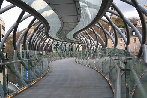
New Footbridge (Edinburgh)

New-footbridge-in-Edinburgh

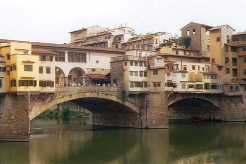
Ponte Vecchio (Florence, Italy)

Ponte-Vecchio-Florence-Italy

Sunday, June 20, 2010

Top 5 Highest Dams in the World

Here’s the list of highest dams in the world. Dam is a construction that built to withstand the rate of water in the river into reservoirs that can be called artificial lakes and become a place of recreation. Often dams are also used to drain water into a hydroelectric power generation. Most of the dam also has a section called the gate to remove unwanted water continuously or gradually.

While dam have lot of benefit, we have to make sure that the dam is strong enough so that it won’t broke. As if the dam is broken it will cause large flood. This will make the people have to repair their house and do water damage cleanup as well as flooded basement cleanup when they have some basement on their house. For the purpose of strong construction these highest dam are made. So, let’s take a look at those highest dams in the world.

highest dam in the world Dam Structure

Dam Structure

5. Tehri Dam, India: 261 meters

Tehri Dam is the primary dam of the Tehri Hydro Development Corporation Ltd., a major hydroelectric project centered near Tehri Town in the state of Uttarakhand in India. Located on the Bhagirathi River, the principal tributary of the sacred River Ganges, the Tehri Dam has a height of 855 feet (261 m), making it the 5th tallest dam in the world.

highest dam in the world Tehri Dam

Tehri Dam

4. Vajont Dam, Italy: 262 meters

One of the highest dams in the world, it is 262 metres (860 ft) high, 27 metres (89 ft) thick at the base and 3.4 metres (11 ft) at the top. Its 1963 over-topping was caused when the designers ignored the geological instability of Monte Toc on the southern side of the basin. Warning signs and negative appraisals during the early stages of filling were disregarded, and the attempt to complete the filling led to a landslide which created a seiche wave that brought massive flooding and destruction to the Piave valley below, wiping out several villages completely.

highest dam in the world Vajont Dam

Vajont Dam

3. Inguri Dam, Georgia: 272 meters

The Inguri Dam is a hydroelectric dam on the Inguri River in Georgia. Currently it is the world’s highest concrete arch dam and the third highest dam in the world with a height of 272 meters (892 ft). It is located north of the town Jvari. It is part of the Inguri hydroelectric power station (HES) which is partially located in the partially recognised Abkhazia.

highest dam in the world Inguri Dam

Inguri Dam

2. Grande Dixence Dam, Switzerland: 284 meters

The Grande Dixence Dam is a concrete gravity dam on the Dixence at the head of the Val d’Hérens in the canton of Valais in Switzerland. With the 285 meters high, it is the tallest gravity dam in the world, tallest dam in Europe and world’s second tallest dams. The dam’s primary purpose is producing hydroelectricity and the four power stations it supplies have a combined capacity of 2069 MW which produce 2 billion kWh annually, enough for 400,000 households.

highest dam in the world Grande Dixence Dam

Grande Dixence Dam

1. Nurek Dam, Tajikistan: 314 meters

The Nurek Dam is an earth fill embankment dam on the Vakhsh River in the central Asian nation of Tajikistan. It is currently the tallest dam in the world. Construction of the dam began in 1961 and was completed in 1980, when Tajikistan was still a republic within the Soviet Union. The Rogun Dam, under construction along the Vakhsh also in Tajikistan, may exceed it when completed, depending on its final height.

highest dam in the world Nurek Dam

Nurek Dam

Dam is created with strong construction so it will be safe for the people that live near the dam. As flood can happen when the structure is leaked or perforated. There is a number of case of failed of a dam. Some just causing a small impact that people have to drying wet basement and cleanup the water from their house, but some of them are causing a number of human victims.